Forth Bridge – Southern Approaches
| < Forth Bridge – Northern Approaches | Δ Index | Hound Point > |
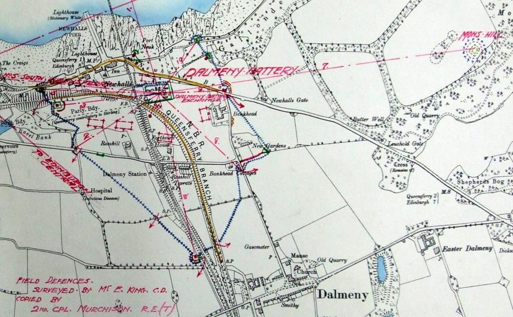
The defences of the southern approaches were intimately combined with the defences of the immediately adjacent Dalmeny Battery.
The defence of the bridge consisted of a single boundary, about 2.1km long in total, formed of barbed wire, with blockhouses and other strongly defended positions at corners and both terminals.
The western end of the boundary, on the shore, was at NT 1340 7827, where a blockhouse covered the road along the front, from South Queensferry. The wire zig-zagged to the upper road along the coast, from west of Dalmeny Station, where a blockhouse at NT 1354 7801 covered a road junction. The boundary continued straight south-east across the fields to a third blockhouse, adjacent to the main rail line, at NT 1423 7791. The wire turned north-east, to Bankhead Cottage which, along with adjacent walls, seems to have been fortified to cover the road running north from Dalmeny village.
The main road from Edinburgh was covered by a further blockhouse at NT 1417 7823. Two further blockhouses, at NT 1410 7836 and NT 1406 7844, closed off the approach from the east.
There was a further firing position on the shore, in front of the Dalmeny Battery searchlights, at NT 1381 7814.
Four infantry concentration areas were marked within the defended perimeter.
 Map showing the complex defences around the southern approaches to the Forth Bridge and the Dalmeny Battery, with the eastern outpost at Mons Hill. The map shows the telephone links; the defence HQ was to the west, in South Queensferry, where the three telephone lines at the western edge of the map converged.
The HQ of the defences was at Dalmeny Battery, the telephone exchange of which was linked to all the blockhouses and strong points, to South Queensferry, and to a subsidiary defended post on the summit of Mons Hill, 1.3km to the east of the battery.
| < Forth Bridge – Northern Approaches | Δ Index | Hound Point > |
top of page
