4 – 1903 Selecting the site
| < 3 – 1900 The need for new naval bases | Δ Index | 5 – 1906 Surveying the site > |
In March 1903 it was announced that a new base was to be built at Rosyth in St Margaret’s Hope, west of Inverkeithing and the new Forth Bridge, on the north shore of the Forth.
From the “Londonderry Sentinel” Tuesday, March 28th 1903.
THE NEW NAVAL BASE ON THE EAST COAST
(From a Correspondent of the “Times.”
Many considerations have doubtless weighed with the Government and their naval advisers in their selection of St. Margaret’s Hope as the site of the additional base made necessary by the enlarged requirements of the Fleet. Of course the strategical must have predominated. In view of the extent to which the south and south-east are supplied and protected by Devonport, Portsmouth, and Chatham, and the Channel Fleet, and the need for a more convenient base for a squadron operating in the German Ocean, some central site on the east coast was obviously desirable. in the event of additional accommodation being provided. It is well known that the claims of Hull and the Humber, of Middlesbrough and the Tees, of Newcastle and the Tyne, have all been duly considered, and in the end have been set aside in favour of St. Margaret’s Hope, near the head of the Firth of Forth.
At Queensferry, where it is crossed by the Forth Bridge, the Firth contracts to a width of less than two miles. Immediately beyond this strait it widens out again to four miles or more until the estuary begins to give place to the river between Culross and Kincardine, a survival of the Gaelic name signifying “the head of the shore.” The first bay on the north side of the Firth to the west of the Queensferry passage is St. Margaret’s Hope, landlocked and protected by the uplands of the north, where from time immemorial sailors have found shelter from the ocean winds and deliverance from the perils of the strong currents of the pass, where the Channel Fleet has often enjoyed a secure and comfortable anchorage, and where for many years one of the coastguard ships has kept watch and ward. The new naval base, therefore, while itself sufficiently far from the ocean to be protected against a surprise attack, yet sufficiently near to send supplies for a fleet operating in the German Ocean, will be able to provide abundant and safe shelter for vessels in need of repair or reprovisioning, or suddenly assailed by heavy gales.
St. Margaret’s Hope, therefore, may be regarded as a base secure in itself, easily accessible and conveniently near the ocean. Monetary considerations would doubtless strengthen the strategical claims. The land overlooking the bay is of the best for agricultural pursuits. For centuries it has been carefully cultivated by intelligent farmers under generous and enterprising landlords. The head or centre of the bay is about equi-distant from North Queensferry and Inverkeithing, both about a mile off, while Dunfermline, the nearest town of considerable importance, is some six miles away.
Other advantages besides strategic suitability, scope for safe anchorage, and cheapness may well have been taken into account. One undoubtedly is the propinquity of the Fife and Lothian coalfields. Another is the accessibility of the site from north, south, east, and west as the result of the railway development which has followed the erection of the Forth Bridge. A further development has been suggested – namely, the utilization of the Forth and Clyde Canal on the other side, so as to make the new base available for the west as well as the east coast.
St. Margaret’s Hope itself does not yield either in historic interest or in natural beauty and attraction to any of the most famous spots in this classic region. It receives its name, of course, from its association with Margaret, the English Princess, who, when her own and her family’s distresses were keenest, was wooed and won by Malcolm Canmore, whose palace was situated in Dunfermline in the woods. Somewhere in the bay now to be connected with a naval port, either immediately behind the rocks jutting out to meet Inchgarvie, or the Barnbougle promontory, on the southern side, or near Rosyth Castle, in such a deep recess as sheltered the storms-tossed Aeneas and his companions on the Libyan Coast, Margaret first set foot on Scottish soil in October, 1069. Because of her romantic history and her many virtues, which earned her sainthood as well as earthly sovereignty, her name, if not her spirit, is everywhere to be found in this district – in the Queensferry, in the St. Margaret’s Stone, on which she is supposed to have rested during her first journey to Dunfermline, in names of streets and churches, and works in the ancient city, and in the Ferry Hills, which “look oure the Forth, the pride of Caledonia.”
“Truly,” it has been said, “the waters of the Forth present an enchanting spectacle as they spread out like an inland sea, so placidly and sweetly after the tide has rolled them through the narrow passage which Inchgarvie guards and which modern engineering science has spanned with a bridge which is one of the wonders of the world – a broad inland sea, stretching out along arm towards the setting sun, as if to detain the soft sunshine which is kissing it good-night. That land-locked sea is called St Margaret’s Hope; and as one gazes on the picture so suggestive of a reverential, soothing, Sabbatic rest and peace he can easily fancy he can hear the name of Margaret sounding through the lullaby of the waters and of the trees and in the evening hymn of the ‘linties’ sang.’”
Now a great transformation is to be effected. The bay is to be converted into one of the homes and shelters of the mightiest navy the world has ever seen as it is made mightier still. It is to become the scene of great workshops and the home of a large host of skilled artisans, with their wives and families. Inverkeithing Harbour, the first creek on the other side of the promontory on the north side of the Forth, may now think that the day of its redemption draws nigh when it will be dredged and made accessible for modern vessels.
—————————-
St Margaret’s Hope was a well-used safe haven for shipping.
The eminent civil engineer Sir Ernest William Moir was involved in the construction of the southern cantilevers of the Forth Bridge.
He recalled that he had looked towards the site of Rosyth at St. Margaret’s Bay to see as many as 400 small trading vessels waiting for a chance to slip out from the Forth into the North Sea.
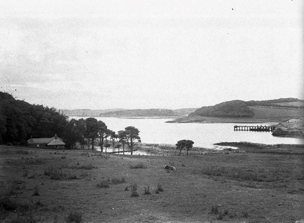 The sheltered bay of St Margaret’s Hope around 1900
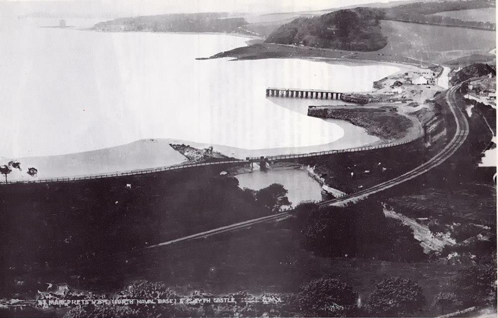 The same view a few years later
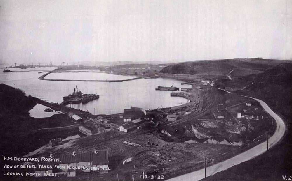 and after WWI in 1922
Initial plans
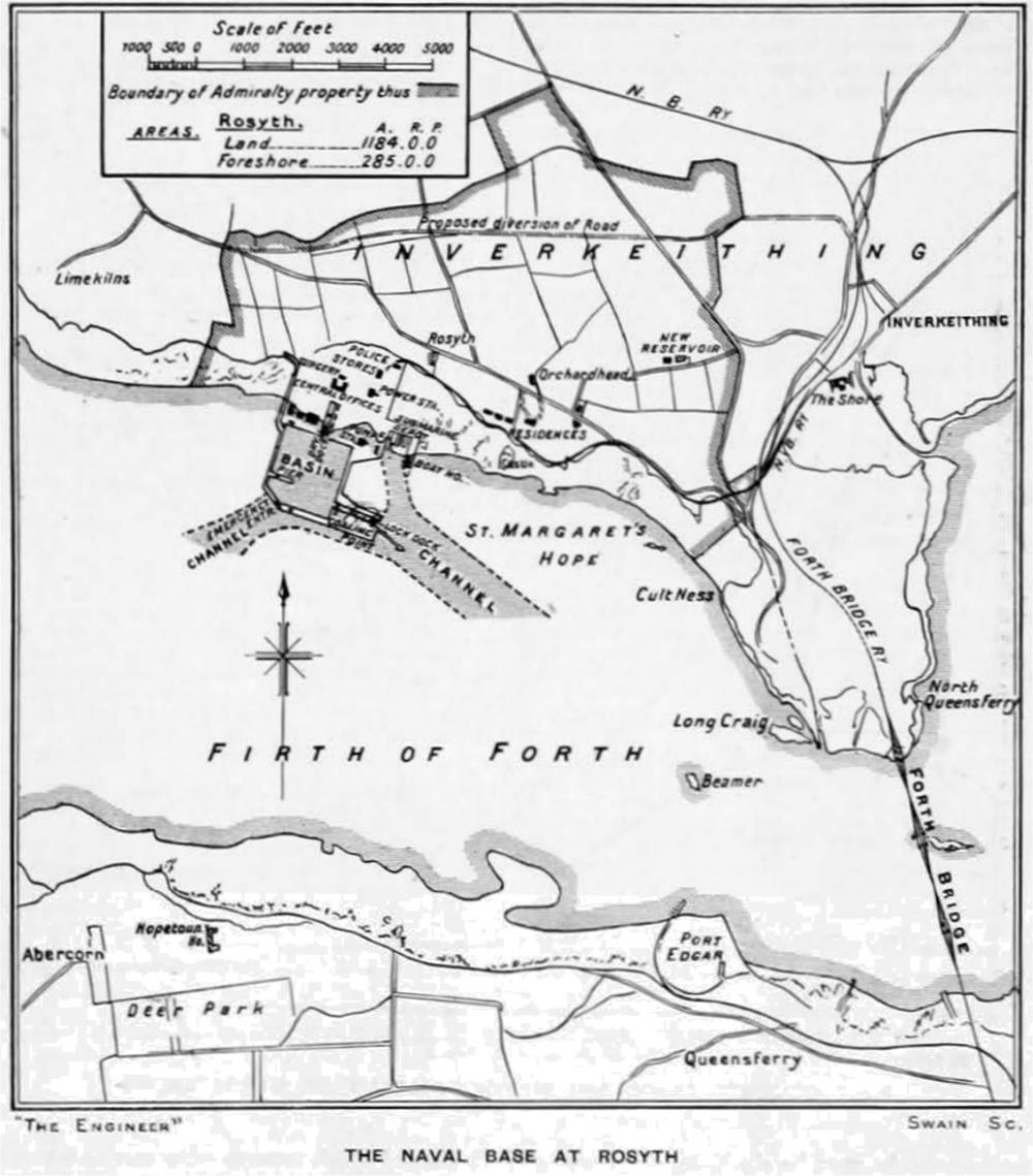 A map of the proposed new dockyard, published in “The Engineer” on 13th March 1908
The original scheme consisted of a large deep-water basin entered via a lock, with one dry dock and an emergency entrance for use in case of damage to the lock. The water level in this basin remained constant at a depth of about 38 ft. (11.5m). There was also a tidal basin for submarines and smaller craft. Cranes, a power station, a pumping station, workshops, offices and storehouses were required.
This first phase could be used immediately with later expansion to the east as required.
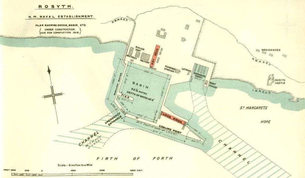 The initial plan of the dockyard from the Dock Book, June 1909, published by the British Admiralty
“For the Information of Officers in H. M. Service Only.”
The decision to build a base at Rosyth was not without its critics, including the First Sea Lord, Lord Fisher, who argued that a successful attack on the Forth Bridge might trap warships on either side.
Political debate led to delay. A supply branch line to the railway between Dunfermline and Queensferry was built in 1905-7, starting near Jamestown and ending west of Rosyth Castle.
Working in the wet
The whole of the proposed site was below the high tide line (much of it was below the low-tide line) so it needed a careful and detailed survey.
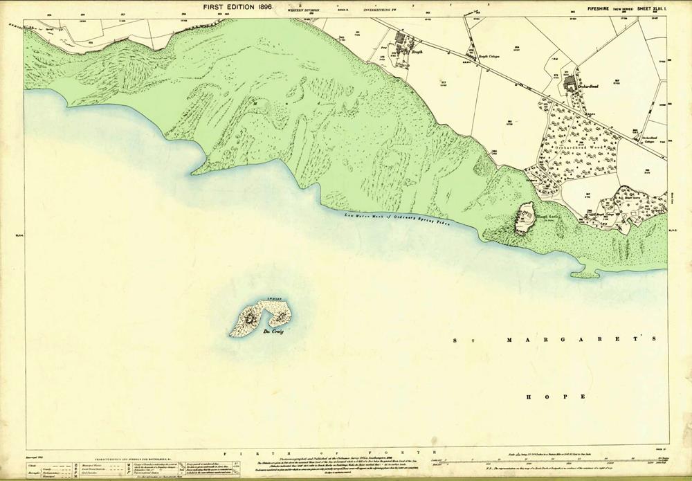 The proposed site in 1900. The blue-edged and green areas are low and high tide lines
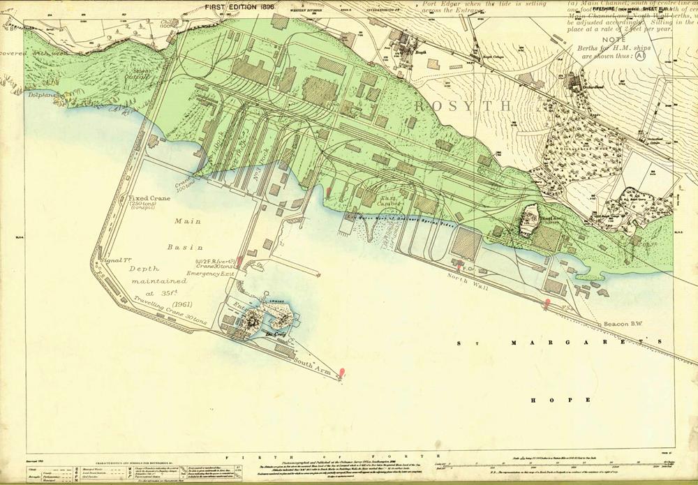 A plan of the completed dockyard overlaid on the same map.
All of the construction work was below the high tide level, and much was below the low tide level.
It was 1909 before works got under way on the planned first phase. The contract was scheduled to be completed within seven years (i.e. by 1916).
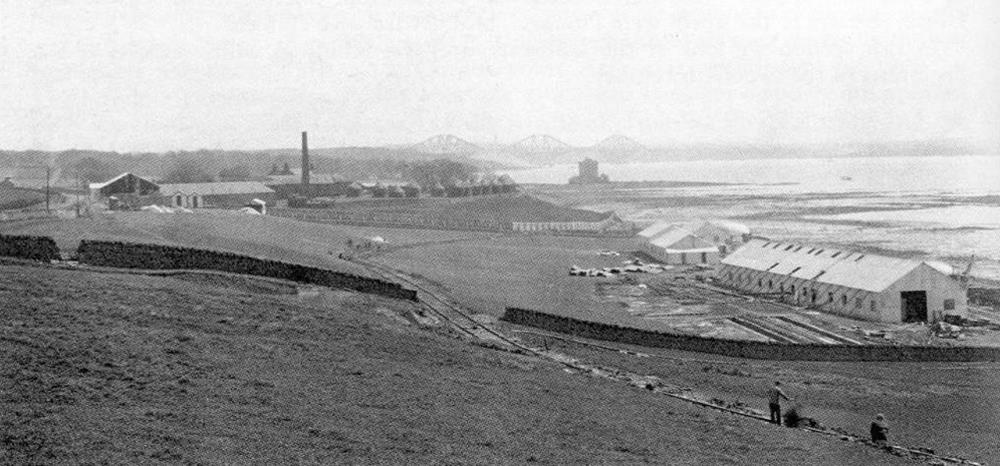 The dockyard site from west showing the first contractors’ workshops – 1909
| < 3 – 1900 The need for new naval bases | Δ Index | 5 – 1906 Surveying the site > |
top of page
